By: Andy Nadler, Agricultural Meteorologist – Global Digital Agronomy Team
With new cases of spray drift being discovered and reported daily, farmers have become hyper-aware of the risk. Drifts cause environmental damage, significant financial losses, and endless aggravation.
Avoiding drift is much more complex than just watching the weather and shutting down when the wind gets too strong. Rather, more subtle conditions can be at play. Vaporization can cause product to volatilize and become airborne hours, or even days after application. Inversions can cause particles to remain suspended for extended periods, being transported by the slightest air movement or change in landscape. When and where these particles eventually get deposited is almost completely unpredictable. Therein lies the challenge.
What Is An inversion?
But first, what is an inversion? During normal non-inversion conditions, the air near the earth’s surface is warmer than the air above. When this warmer, more buoyant air rises, it gets replaced with cooler, denser air from above, resulting in normal circulation. A temperature inversion occurs when temperatures near the surface becomes cooler than those aloft. When the cool, dense air is concentrated near the ground, there is very little vertical movement of air, causing particles to become suspended.
Detecting inversions has traditionally been a matter of observing clues that are often associated with their presence – clear skies, calm winds, high pressure, sometimes the presence of dew, frost, or low-lying fog. However, there is no clear indicator of when an inversion is occurring or will occur. Therefore, the onus is on the operator to weigh the risks. Given the stakes, this can be very stressful.
How Farmers Edge is Addressing Inversions
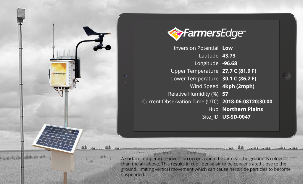
Farmers Edge is always looking for new ways to leverage technology that can help farmers make better decisions – including the decision of when to spray. In addition to our existing spray tools like field-centric wind speed, direction and Delta-T*, we are looking closely at inversions. How common are they? How widespread? How accurately can they be predicted?
To help answer these questions, we have developed a Regional Inversion Monitoring Network. This network consists of over 30 weather stations (20 in Canada, 8 in the U.S., and 5 in Australia) equipped with additional sensors that report temperature inversions. Since this is such an important issue to growers everywhere, we have made this information available to everyone for 2018!
You can access the Farmers Edge Regional Inversion Monitoring Network here.
Farmers can now consult the regional inversion monitoring map to familiarize themselves with the presence of inversions and when they are occurring in real-time. Of course, this is a regional network, therefore results may not be representative of individual fields. Data collected during the 2018 growing season will be used by our R&D team to better understand the spatial characteristics of inversions and to develop improved methods to forecast them – another tool to help farmers make better decisions is in the works.

*Delta-T is an index of acceptable spraying conditions based on evaporation rate and droplet lifetime.